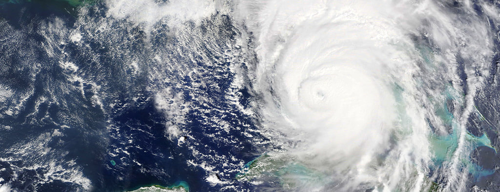
Hurricane Beryl became one of the most notable names in the 2024 Atlantic hurricane season, capturing worldwide attention as it quickly evolved into a Category 5 hurricane.
Below, we’ll take a comprehensive look at Hurricane Beryl’s timeline, its path across the Atlantic, the impact it left in its wake, and the remarkable data gathered during its lifecycle.
From its explosive start in the Main Development Region (MDR) of the Atlantic to its final landfall near Matagorda, Texas, Beryl demonstrated the raw force of nature paired with the critical need for preparedness.
When Did Hurricane Beryl Form in 2024?
Hurricane Beryl officially formed on June 28, 2024. This marked the beginning of its 14-day existence, during which it transitioned from a tropical depression to a catastrophic hurricane. Initially, it developed in the deep tropical Atlantic, a region known as the Main Development Region (MDR).
The storm quickly gained strength, evolving into a tropical storm by the evening of June 28 and achieving hurricane status on June 29. From there, its rapid intensification set the stage for what would become a historic storm.
Path of Hurricane Beryl in 2024
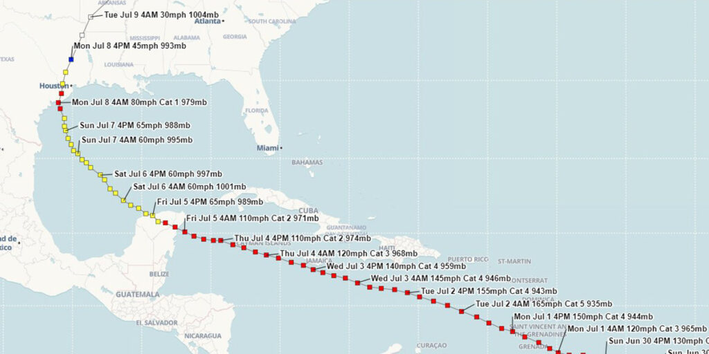
Hurricane Beryl’s progression was both fierce and geographically extensive, impacting multiple regions along its path. Here’s the timeline of its movement and intensification:
- June 28: Tropical Depression Two develops in the MDR of the Atlantic. The tropical cyclone strengthens into Tropical Storm Beryl later that evening.
- June 29: Tropical Storm Beryl quickly develops into a hurricane.
- July 1: Beryl intensified into a Category 4 hurricane and hit the island of Carriacou in Grenada, causing major disruptions. The storm later strengthened into a Category 5 hurricane in the Eastern Caribbean Sea.
- July 3: Beryl skirts just south of Jamaica as a Category 4 hurricane.
- July 5: The hurricane made its second landfall on the Yucatán Peninsula as a high-end Category 2 hurricane, where it briefly weakened.
- July 8: Beryl regained hurricane strength and made its final landfall near Matagorda, Texas, with sustained winds of 80 mph.
The storm continued to weaken as it moved inland, transitioning into a tropical depression on July 9 and later into a post-tropical cyclone as it moved across the Northeastern U.S.
Where Did Hurricane Beryl Make Landfall?
Hurricane Beryl made a notable final landfall near Matagorda, Texas, on July 8, 2024. At the time, it had sustained winds of approximately 80 mph (70 knots) and a central pressure of 979 millibars.
Despite its final landfall being at minimal hurricane strength, the storm had already left a trail of destruction across its previous locations, including the Caribbean and sections of Mexico.
What Category Was Hurricane Beryl?
Hurricane Beryl’s peak intensity was categorized as Category 5 on the Saffir-Simpson Hurricane Wind Scale. Achieving this status in the Eastern Caribbean, it became not only the first Category 5 hurricane of the 2024 season but also a record-setting early-season storm of its magnitude.
Wind speeds at its peak surpassed 160 mph, underscoring the extreme strength and rapid intensification of this system.
Impacts of Hurricane Beryl

While Beryl weakened during its final landfall, its earlier impacts were severe. Below are the key aspects of the damage it caused across different regions:
Wind Speeds and Pressure
- Maximum wind speeds exceeded 160 mph while it was a Category 5 hurricane.
- Sustained winds reached 80 mph in Matagorda, Texas, with gusts up to 70 mph recorded inland.
- Coastal regions in Southeast Texas and extreme southwestern Louisiana also reported tropical storm-force winds, with gusts ranging from 30 to 70 mph.
Storm Surge and Flooding
- Storm surges between 2.5 to 3 feet were reported along the Texas and Louisiana coasts. Areas like Sea Rim State Park and Holly Beach experienced significant flooding and debris accumulation.
- Highways and secondary roads across the impacted areas were submerged, leading to disruptions in transportation.
Rainfall Totals
- Hurricane Beryl dropped 3 to 6 inches of rainfall across Southeast Texas. Central and Southern Louisiana saw lower totals of approximately 2 inches.
Tornado Activity
- One EF2 tornado was reported in Jasper, Texas, resulting in one injury. Tornado activity can be a potential secondary threat posed by tropical systems, especially within their outer bands.
Frequently Asked Questions
Was Hurricane Beryl declared a Federal Disaster?
According to the Federal Register, a major disaster declaration was issued for the state of Texas due to severe storms and flooding from 07/01/2024 through 07/09/2024. This declaration allows for federal assistance to support recovery efforts in the affected regions, including infrastructure repairs and aid for residents and businesses.
How did Hurricane Beryl develop?
The storm developed in the Main Development Region (MDR) of the Atlantic Ocean on June 28. Favorable conditions, including warm sea surface temperatures and low wind shear, contributed to its rapid intensification into a powerful system.
What was the strength of Hurricane Beryl?
Hurricane Beryl reached its peak strength as a Category 5 hurricane, with sustained winds exceeding 160 mph in the Caribbean.
What was the impact of Hurricane Beryl?
The storm caused widespread flooding, disrupted transportation, and left significant wind damage in its path. Several areas experienced storm surge-related destruction, and one EF2 tornado was reported.
Was Hurricane Beryl the earliest Category 5 hurricane on record?
Hurricane Beryl was the earliest Category 5 hurricane for the Atlantic season, marking a significant event in meteorological history.
Its rapid intensification was closely monitored, with satellite data from NASA’s Global Precipitation Measurement (GPM) mission providing critical insights. Beryl’s formation highlighted the increasing unpredictability of tropical weather patterns seen in recent years.
Who named Hurricane Beryl?
Hurricane names are chosen from a pre-determined list managed by the World Meteorological Organization (WMO). The name “Beryl” was previously used in various hurricane seasons, making its return to the 2024 naming list. Should a storm name cause significant destruction, it is retired to prevent reuse in future seasons.
Lessons from Hurricane Beryl
Beryl serves as a reminder of the power and unpredictability of nature. While its impacts were devastating, advanced forecasting efforts and public readiness helped mitigate potential loss of life.
For future tropical storms, preparedness remains crucial. Monitoring weather warnings, developing evacuation plans, and understanding the risks of storm surges and flooding will help communities be more resilient in the face of similar weather events.


